Area History
Daniel Boone in the Breaks and Southwest Virginia
Before Cumberland Gap made him famous, Daniel Boone tried the back door to Kentucky: down the Russell Fork, past the Breaks, and into a winter he never forgot.
- FIRST TRIP
- Fall 1767
- ROUTE
- Down the Russell Fork past the Breaks
- WINTER CAMP
- A salt spring near present Prestonsburg, KY
- BREAKS FROM THE LODGE
- 20 to 25 min, 10 mi
Quick Answer
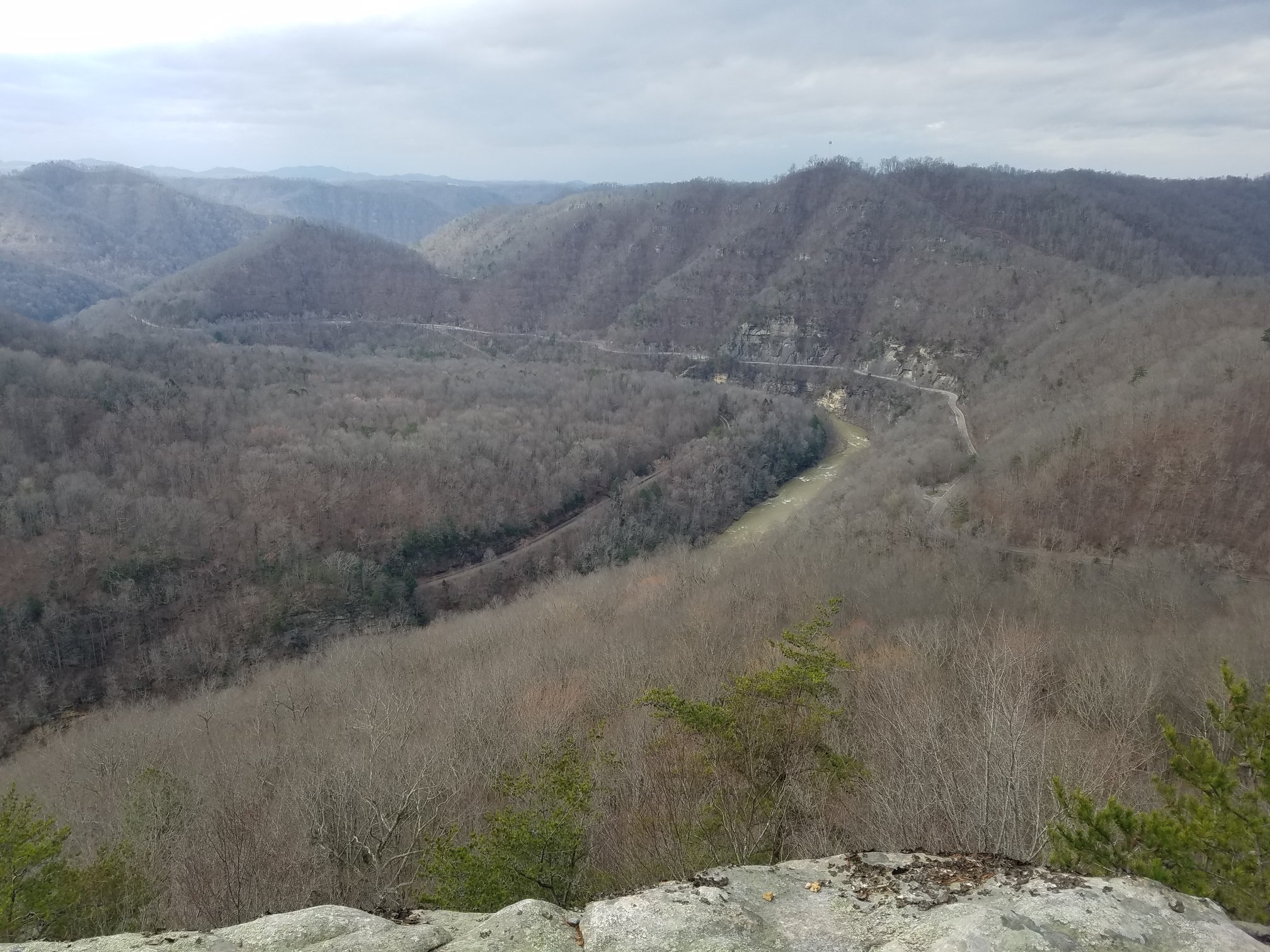
Daniel Boone's first attempt to reach Kentucky came through this country. In the fall of 1767, Boone and William Hill, and by many accounts his brother Squire Boone, crossed the mountains from North Carolina and struck the Russell Fork of the Big Sandy. Reasoning that the river must run to the Ohio, they followed it northwest past the rim of the Breaks and on to a salt spring near present-day Prestonsburg, Kentucky, where a snowstorm trapped them for the winter. They went home in the spring of 1768 without knowing they had been in Kentucky. Breaks Interstate Park credits Boone with naming the Breaks on that trip. Boone later lived at Castle's Woods on the Clinch River in Southwest Virginia from 1773 to 1775, where his son James was killed and from where he set out to help open Kentucky.
The Man Before the Legend
In 1767 Daniel Boone was in his early thirties, a hunter and farmer living in the Yadkin River valley of North Carolina. He had heard about Kentucky for years. During General Edward Braddock's 1755 campaign in the French and Indian War, he had met a trader named John Finley, who had been to the country south of the Ohio and talked about it like a promised land: cane, grass, salt licks, and more game than a man could carry.
Boone wanted to see it. The question was how to get there. The mountains between North Carolina and Kentucky are not a single wall but ridge after ridge, and the passes through them were known to only a few.
The Long Hunt of 1767
In the fall of 1767, Boone set out with William Hill, and by many accounts with his brother Squire Boone. They crossed into the valleys of the Holston and the Clinch and kept working northwest until they reached the headwaters of a branch of the Big Sandy River. That branch was the Russell Fork.
Their logic was simple and sound. Water runs downhill, and in that direction all of it ends in the Ohio. Follow the river and you reach the Ohio country. So they followed it, down the Russell Fork past the place where Haysi now stands, according to some local timelines, and on toward the gap in Pine Mountain.
The gorge at the Breaks would not be walked. Accounts of the trip describe the party skirting the canyon rim through laurel and rock, then following a buffalo trace for some fifty miles beyond it. Kentucky tradition holds that Boone's first steps in Kentucky came near present-day Elkhorn City, where the Russell Fork leaves the gorge.
Naming the Breaks
Breaks Interstate Park credits Boone with discovering this break in Pine Mountain on the 1767 trip and giving the place its name. Pine Mountain runs 125 miles with only a handful of places where it can be crossed, and pioneers called those gaps breaks.
No document in Boone's own hand has surfaced that records him naming it, so the claim rests on the park's account and long tradition. What is certain is that he came through here, that the canyon turned him aside, and that the name has stuck to the place ever since.
Snowbound at the Salt Spring
Past the Breaks, the buffalo trace led the party to a large salt spring west of present-day Prestonsburg, Kentucky, on the waters of Middle Creek. A heavy snowstorm caught them there, and they spent the winter.
It turned out to be a lucky place to be stuck. Game came to the salt from every direction, and the hunters barely had to leave camp. Boone saw buffalo there, by tradition the first he had ever seen. The spring later became known as Boone's salt spring, and salt making there grew into an early industry of the region.
In the spring of 1768 the party went home to the Yadkin with their furs. They had not reached the Ohio. Boone did not know until years later that the river he had wintered on was the Big Sandy, and that he had already been in Kentucky.
Why Boone Did Not Come Back This Way
The Russell Fork route had a fatal flaw. The Big Sandy's branches twist back and forth through steep, narrow valleys, and the gorge at the Breaks is impassable on foot along the river. It was a hunter's road, not a settler's road.
In the winter of 1768 to 1769, John Finley turned up at Boone's cabin. In May 1769 the two of them, with John Stewart, Joseph Holden, James Mooney, and William Cooley, set out again, this time through Moccasin Gap and Cumberland Gap. That route worked, and it is the one history remembers. But Boone had already seen the back door, and it was here.
Castle's Woods and the Clinch
Boone's deepest ties to Southwest Virginia came a few years later, on the Clinch River at Castle's Woods, today's Castlewood in Russell County. First settled in 1769, Castle's Woods was the first settlement on the Clinch and the westernmost outpost of Virginia. Its leading man was Captain William Russell.
In the summer of 1773 Boone met Russell in the Clinch Valley, and the two agreed to lead a party of families to settle Kentucky by way of Cumberland Gap. Boone's group left the Yadkin on September 25, 1773.
Along the way Boone sent his seventeen-year-old son James, with two young men named Mendenhall, north to Russell's at Castle's Woods for flour and farm tools. Returning with Russell's son Henry and others, James's party camped in Powell Valley short of the main company. At dawn on October 10, 1773, they were attacked. James Boone and Henry Russell were killed.
The settlement attempt collapsed. Boone took his family back to the Clinch and wintered in a cabin near Castle's Woods. It was the hardest season of his life.
Defending the Clinch in 1774
Boone stayed on the Clinch through 1774, as tensions with the Shawnee became open war. That summer, during what became known as Lord Dunmore's War, Boone and Michael Stoner were sent from Castle's Woods to Kentucky to warn surveyors in the field to get out. They covered some 800 miles of wilderness in about two months.
Back on the Clinch, Boone took command of Moore's Fort, one of the small forts raised along the river to protect the settlements, and helped hold the frontier through the fall.
The Road He Finally Opened
In March 1775, Boone led a party of axmen from the Long Island of the Holston through Cumberland Gap to mark the trail that became the Wilderness Road, and he founded Boonesborough on the Kentucky River that spring. The road carried tens of thousands of settlers west over the decades that followed.
It started with failures, and some of the most important ones happened here: the winter of 1767 on the Big Sandy, the gorge that would not be walked, and the grief of 1773 on the Clinch. Southwest Virginia is where Daniel Boone learned the mountains the hard way.
Following Boone Today
- The Breaks overlooks. Stand on the rim of the gorge that turned Boone aside in 1767. Breaks Interstate Park is 10 miles, 20 to 25 minutes from Flannagan Lodge.
- The Russell Fork at Haysi. The river Boone followed downstream, flowing right past the town.
- Elkhorn City, Kentucky. Where the Russell Fork leaves the gorge, and where Kentucky tradition places Boone's first steps in the state.
- Castlewood, Virginia. The old Castle's Woods settlement on the Clinch River in Russell County, where Boone lived from 1773 to 1775.
- Cumberland Gap. The route that finally worked, at the far southwestern end of the same Pine Mountain system.
Key Facts
| First trip toward Kentucky | Fall 1767, from the Yadkin River valley of North Carolina |
|---|---|
| Companions | William Hill, and by many accounts Squire Boone |
| River followed | Russell Fork of the Big Sandy |
| The Breaks | Skirted the gorge rim; park tradition credits Boone with the name |
| Winter camp | Salt spring west of present Prestonsburg, Kentucky, on Middle Creek |
| Returned home | Spring 1768, not knowing he had reached Kentucky |
| Second attempt | May 1769 with John Finley, by way of Cumberland Gap |
| Castle's Woods | Today's Castlewood, Virginia; Boone lived nearby 1773 to 1775 |
| Son killed | James Boone, age 17, October 10, 1773, in Powell Valley |
| 1774 | Warned Kentucky surveyors during Dunmore's War; commanded Moore's Fort on the Clinch |
| 1775 | Marked the Wilderness Road and founded Boonesborough |
| Breaks Interstate Park from Flannagan Lodge | 10 miles, 20 to 25 minutes |
Stay Where Boone's First Trail Ran
Flannagan Lodge sits on Big Ridge Road, State Route 63, just outside Haysi, above the river Boone followed in 1767 and 10 miles, 20 to 25 minutes from the gorge that turned him aside.
It was taken down to the studs and fully remodeled in 2022 and 2023, and it was built for privacy: a private entrance, a private guest bathroom, and a private deck that belongs to you for the length of your stay. The Breaks Room is named for the canyon on this page.
Make Flannagan Lodge your basecamp.
More Area History
Discover Dickenson County
The hub for every story: the county, the Breaks, Boone, Swift's silver, Splashdam, Haysi, and Ralph Stanley.
Splashdam History
The 1909 log drive, the June 13, 1932 mine explosion, and the 1957 flood that ended a coal town.
Breaks Interstate Park History
Pine Mountain, Daniel Boone, the Battle of the Breaks, and the 1954 compact that made a two-state park.
How Haysi Got Its Name
Hayter and Sifers, the 1900 post office, and the legend of shouting Hey, Si across the river.
Swift's Lost Silver Mine
The journal, the forked oak, the blind man's search, and 250 years of hunting around the Breaks.
Dr. Ralph Stanley
Big Spraddle Creek, the Stanley Brothers, the museum in Clintwood, and the Hills of Home Festival.
How Dickenson County Was Born
The 1879 meeting at Nora, the 1880 act, and why the last county in Virginia is called Virginia's Baby.
Flannagan Dam History
Why the Corps built a 250-foot dam on the Pound River, and how it runs today.
John W. Flannagan Jr.
The congressman from the Ninth District whose name the dam and reservoir carry.
Daniel Boone FAQ
Did Daniel Boone really visit the Breaks?
Yes. In the fall of 1767, on his first attempt to reach Kentucky, Daniel Boone followed the Russell Fork of the Big Sandy past the rim of the Breaks gorge. Breaks Interstate Park credits him with discovering this break in Pine Mountain and giving the area its name.
Did Daniel Boone name the Breaks?
Breaks Interstate Park credits Boone with naming the Breaks in 1767, and the tradition is long-standing. No document in Boone's own hand recording the name has been found, so the claim rests on the park's account and local tradition.
What route did Daniel Boone take in 1767?
Boone crossed from North Carolina into the Holston and Clinch valleys, reached the Russell Fork, and followed it northwest past the Breaks, reasoning it would lead to the Ohio. Beyond the gorge he followed a buffalo trace to a salt spring west of present-day Prestonsburg, Kentucky.
Where did Daniel Boone spend the winter of 1767?
At a salt spring on the waters of Middle Creek, west of present-day Prestonsburg, Kentucky, where a snowstorm trapped his party. Game came to the salt, and Boone returned home in the spring of 1768 without realizing he had been in Kentucky.
Why did Boone use Cumberland Gap instead of the Breaks?
The Russell Fork and Big Sandy route wound through steep, twisting valleys, and the gorge at the Breaks could not be followed on foot. In 1769 John Finley guided Boone through Cumberland Gap, a far better passage, and that became the road to Kentucky.
What happened to Daniel Boone at Castle's Woods?
Boone lived near Castle's Woods, today's Castlewood, Virginia, on the Clinch River from 1773 to 1775. His son James was killed on October 10, 1773 while bringing supplies from Castle's Woods, and in 1774 Boone warned Kentucky surveyors during Dunmore's War and commanded Moore's Fort.
How far is Breaks Interstate Park from Flannagan Lodge?
10 miles, 20 to 25 minutes. Flannagan Lodge is a private guest suite on State Route 63 just outside Haysi, Virginia, bookable on Airbnb and VRBO.
Sources and References
- A History of the Daniel Boone National Forest, U.S. Forest Service, chapters 3 and 4.
- Pike County Kentucky Historical Society, "Eastern Kentucky Salt Works."
- Willard Rouse Jillson, "Squire Boone, 1744 to 1815," The Filson Club History Quarterly, Vol. 16, No. 3.
- James William Hagy, "The First Attempt to Settle Kentucky: Boone in Virginia," The Filson Club History Quarterly, Vol. 44, No. 3.
- Lewis Preston Summers and Emory L. Hamilton, Historical Sketches of Southwest Virginia, Historical Society of Southwest Virginia.
- John Filson, "The Adventures of Col. Daniel Boon," 1784.
- Breaks Interstate Park Commission, park history.
- Scott County Historical Society, "James Boone."
This page was researched and written by Joseph Boyd for Flannagan Lodge from the sources listed above. Boone's 1767 route and companions are reported differently in different accounts, and we have said so in the text. If you find an error or know of a document that settles who named the Breaks, please contact us and we will update this page and credit the contribution.
Last reviewed: November 2026