Area History
Breaks Interstate Park: A History of the Grand Canyon of the South
How a gap in a 125-mile mountain became a hunting ground, a frontier landmark, a railroad battleground, a failed national park, and finally one of only two interstate parks in the United States.
- ESTABLISHED
- Compact 1954, opened 1955
- SIZE
- Roughly 4,500 acres, two states
- THE CANYON
- 5 miles long, up to about 1,600 ft deep
- FROM FLANNAGAN LODGE
- 20 to 25 min, 10 mi
Quick Answer
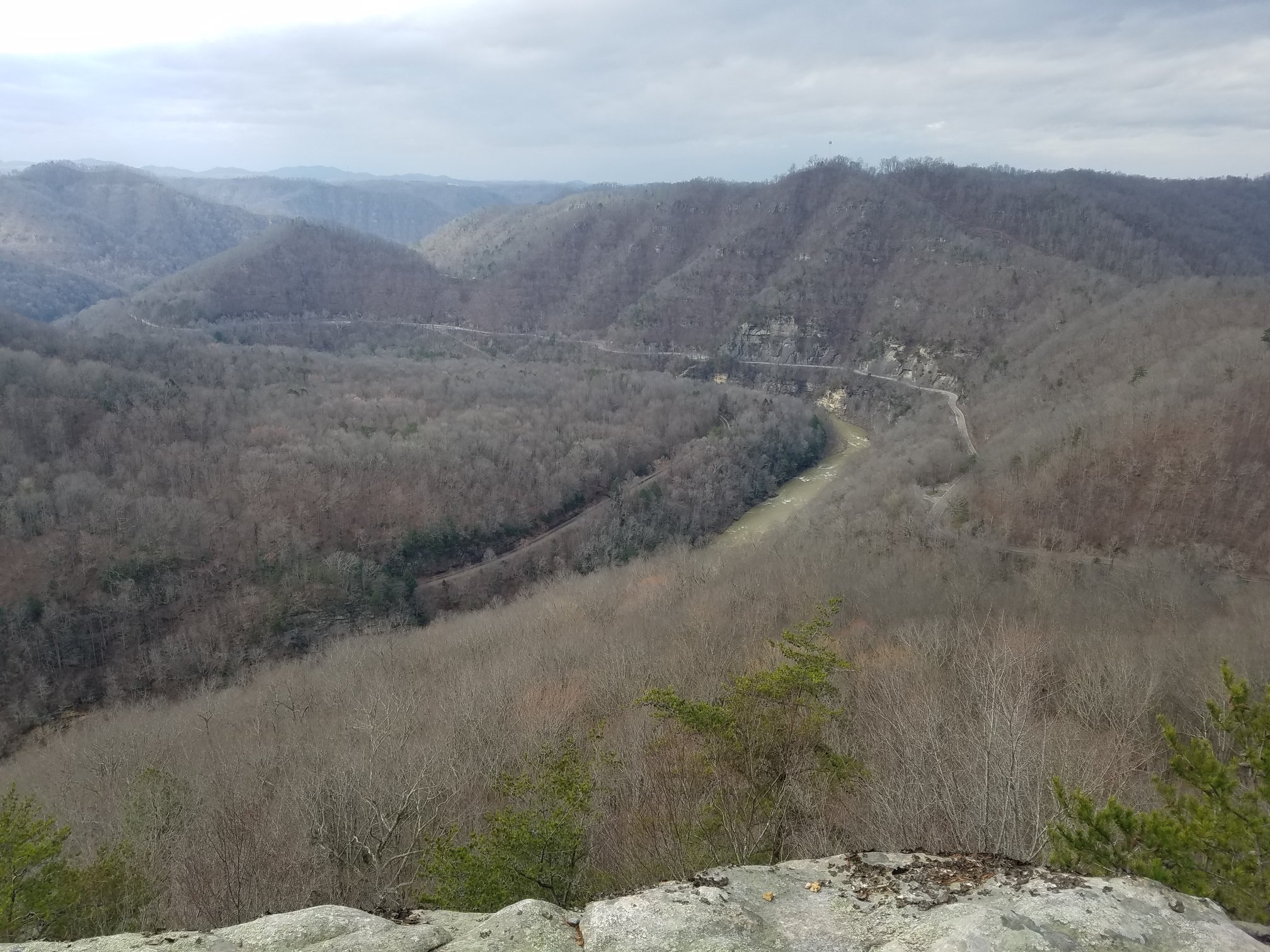
Breaks Interstate Park straddles the Virginia and Kentucky line at the northeastern end of Pine Mountain, in Dickenson and Buchanan Counties, Virginia and Pike County, Kentucky. It is one of only two interstate parks in the United States, governed by a compact that Virginia and Kentucky passed in 1954 and that Congress consented to on July 27, 1954. The park opened in 1955. Its centerpiece is Breaks Canyon, cut by the Russell Fork River through Pine Mountain, five miles long and up to roughly 1,600 feet deep, widely called the Grand Canyon of the South. The name comes from the gap, or break, in Pine Mountain that the river carved, one of the very few places the 125-mile ridge can be crossed. The park covers roughly 4,500 acres and offers overlooks, hiking, mountain biking, rock climbing, elk tours, and, on the first four full weekends of October, some of the most difficult commercially run whitewater in the eastern United States.
A Ridge You Cannot Cross
Pine Mountain runs 125 miles. It is not a peak or a cluster of peaks. It is one continuous, scallop-edged ridge, the northwestern lip of a slab of rock thousands of feet thick that was shoved up and over the rocks beneath it when the African and North American plates collided and built the Appalachians. Geologists call the structure a thrust fault. What matters on the ground is simpler: for most of its length, you cannot get over it.
In only a handful of places along those 125 miles can a person, an animal, or a river pass through. Pioneers called those places breaks. At the southwestern end of the ridge lies the most famous one, Cumberland Gap. At the northeastern end lies this one.
The rock exposed in the canyon walls is Pennsylvanian sandstone, laid down roughly 300 million years ago, along with shale and the coal seams that would later define the economy of every county around it. The park's own history tells it as an inland sea receding around 180 million years ago and the river working ever since. Whichever figure you take, the sequence is the same: sediment laid flat, mountains built by collision, and a river that kept cutting downward while the land rose around it.
Softer rock wore away. Harder rock stayed. What was left standing in the middle of the gorge is the formation called the Towers, a pyramid-shaped mountain capped in sheared sandstone cliffs, nearly surrounded by the Russell Fork looping around it like a moat.
Hunting Ground and Frontier Landmark
Long before it was a park, this was hunting territory for the Shawnee and the Cherokee. The canyon and the ridge above it sat in country that supported bear, elk, deer, and turkey in numbers that drew people back season after season.
The eighteenth century added its legends. One of the most durable in this part of the mountains is the story of John Swift and his lost silver mines, a treasure tale that has sent people scrambling over these rocks for two centuries and has never produced silver.
The park's own account credits Daniel Boone with the name. In 1767, working westward and looking for a usable passage through Pine Mountain toward Kentucky and the Ohio Valley, Boone reached this gap. By that telling, he found the single break in the 125-mile wall and gave the place the name it still carries: The Breaks.
Whether or not Boone coined the word, the gorge defeated him as a route. Accounts of the attempt describe copperheads, rattlesnakes, and a river that would not be walked. Boone eventually went west by a different door.
The Battle of the Breaks
For a hundred and fifty years after Boone, the canyon stayed effectively unreachable, and that saved it. Then the railroads came for it.
In the early twentieth century two companies wanted the right-of-way through the gorge: the Chesapeake and Ohio, pushing to widen its reach into the coalfields, and the Clinchfield, under George L. Carter. The passage was so tight that only one line could physically occupy it. The competition became a race, and it is remembered locally as the Battle of the Breaks.
The Clinchfield won it, and then had to build it. Crews blasted a route through rock along the canyon wall, boring the Towers Tunnel, roughly 900 feet long, beneath the saddle between the Towers and the Chimney so the line could avoid the river's tight meander, and driving the Stateline Tunnel at the border. The labor was largely immigrant, much of it Russian and Italian, working in a language most of them did not share with their foremen. Conflict on the job was frequent.
George Carter drove the last spike on February 9, 1915. The Carolina, Clinchfield and Ohio was the last major Class I railroad built east of the Mississippi, and at the time it was the most expensive American line ever built on a per-foot basis, in large part because of what the Breaks cost to get through.
The tracks are still there. CSX runs coal through the gorge today on what is now the Kingsport Subdivision. If you stand at the Towers Overlook long enough you will eventually hear a train inside the mountain.
The Park That Almost Was a National Park
By the early twentieth century the country around the canyon had been worked hard. The timber was cut, in this valley by the Yellow Poplar Lumber Company, which built a splash dam downriver at Bartlick and drove 36,000 logs through this gorge on December 4, 1909. Coal followed the railroad. Erosion and water quality in the Russell Fork watershed suffered accordingly.
Pine Mountain itself got a reprieve by geological accident. It held no marketable coal. Ridges all around it were opened and mined while Pine Mountain was left largely alone.
The preservation effort found its first serious champion in Kelley Day, a Pikeville businessman and former mayor who served as vice president of the Breaks Reserve and Reforestation Association. Day pushed for the canyon and some 15,000 adjoining acres of Jefferson National Forest to be set aside as a national park.
It failed. The decisive obstacle was that the Clinchfield Railroad owned a strip of land running straight through the middle of the proposed acreage. A national park cannot easily be assembled around a working coal railroad.
The campaign did not die with the national park idea. Joe Creason, a journalist at the Louisville Courier-Journal, took up the cause and kept the canyon in front of Kentucky readers. He wrote about the beauty, and he wrote just as hard about the roads, which he described as narrow, deeply rutted, and dangerous, hugging the very edge of the gorge.
The roads were the real barrier. John Fox Jr., who wrote The Trail of the Lonesome Pine, needed three days by horse-drawn buckboard in 1900 to reach the Breaks from Big Stone Gap, seventy miles away. It was not until after the Second World War, when two-lane roads were pushed into the coal country, that the traveling public could get here at all.
Two States, One Park
What eventually happened here had almost no precedent.
Rather than each state creating its own park on its own side of the line, Virginia and Kentucky wrote an interstate compact. Both legislatures passed the Breaks Interstate Park Compact in 1954. Because a compact between states requires federal consent, Congress granted it by public law on July 27, 1954. The compact created the Breaks Interstate Park Commission, a body corporate with commissioners appointed by both governors, empowered to acquire land, develop the park, and operate it jointly.
The park opened in 1955. Accounts of the dedication place it on September 5 of that year. The Rhododendron Lodge came in the 1960s.
Breaks is one of only two interstate parks in the United States operated jointly under a compact rather than as two separate state park units. The other is Palisades Interstate Park on the New York and New Jersey line. The Virginia Department of Conservation and Recreation and the Kentucky Department of Parks remain partner organizations, and the funding structure is unusual enough that the park depends more heavily on earned revenue than a typical state park does.
What the River Does in October
The Russell Fork drops about 350 feet across the five miles of the gorge, and it does it through house-sized boulders, undercut ledges, and pool-and-drop chutes.
For most of the year that is a technical Class IV to V creek run at low water, and at very low flows you can see into the caves at Fist and beneath El Horrendo. Then the Army Corps of Engineers draws down Flannagan Reservoir.
On each Saturday and Sunday of the first four full weekends in October, water is released from John W. Flannagan Dam on the Pound River, roughly 800 to 1,100 cubic feet per second into the Russell Fork, with the final weekend running higher. That is enough to cover the boulder gardens, and it turns the gorge into Class V and up. Paddlers come from across the country and overseas for it.
The rapids carry names that tell you what to expect: Fist, Broken Nose, Triple Drop, Twenty Stitches, Tower Falls, The Maze, Climax, and El Horrendo, which is exactly what it sounds like. The Lord of the Fork race runs on the last release weekend, and spectators hike out along the railroad tracks to watch the finish at Climax.
There is a symmetry worth noticing. In 1909 a lumber company impounded water above this gorge and released it all at once to move 36,000 logs through the canyon. Today the Corps impounds water above the same gorge and releases it on a schedule to move kayaks. Same river, same mechanism, different cargo.
This is expert water. Run it with a licensed outfitter unless you are certain you belong there.
The Elk Came Back
Eastern elk were native to these mountains and were gone by the 1800s.
Restoration began across the state line. In 1997 Kentucky released Rocky Mountain elk in its eastern counties, and that herd grew past 13,000. Virginia started its own program in 2012, and seventy-five elk were brought over from Kentucky in partnership with the Virginia Department of Wildlife Resources. The release zone was reclaimed surface mine land across Buchanan, Wise, and Dickenson Counties, replanted from invasive cover to native grasses to recreate something like the habitat elk had here originally.
The Virginia herd now numbers more than 250. In 2023 elk were seen inside Breaks Interstate Park for the first time in more than a century.
The park runs guided bus tours to the Virginia elk restoration zone on selected dates in spring and fall, with a meal included. Tours are not offered in midsummer, when calves are most vulnerable. Book ahead. They fill.
The Park Today
Roughly 4,500 acres across two states. Seven overlooks. More than twenty miles of hiking trails, from paved rim walks to the strenuous descent to the canyon floor. A stacked-loop mountain bike system offering close to twelve miles of riding. Laurel Lake with pedal boats, canoes, and kayaks. A campground with full hookups, cottages, cabins, a yurt, the Rhododendron Lodge and restaurant, an amphitheater, a seasonal water park, and a canyon rim zipline.
The sandstone here is good enough that the park, working with the Central Appalachian Climbers Coalition, has developed over 300 climbing routes, on rock often compared to the New River Gorge.
Wildlife is genuinely abundant. Black bear, bobcat, red fox, white-tailed deer, and the elk. Peregrine falcons were released in the park in 2007. Hawks over the gorge are routine and bald eagles are possible.
The park is open year round, though weather closes it occasionally. There is a day-use fee per vehicle. Check current rates and hours with the park directly before you drive out, and note that cell service in and around the canyon is thin to nonexistent. Download your maps before you leave.
Key Facts
| Official name | Breaks Interstate Park |
|---|---|
| Nickname | The Grand Canyon of the South |
| States | Virginia and Kentucky |
| Counties | Dickenson and Buchanan, Virginia. Pike County, Kentucky. |
| Governance | Breaks Interstate Park Commission, under the Breaks Interstate Park Compact of 1954 |
| Congressional consent | Public law approved July 27, 1954 |
| Opened | 1955. Dedication accounts give September 5, 1955. |
| Distinction | One of only two interstate parks in the United States |
| The other one | Palisades Interstate Park, New York and New Jersey |
| Size | Roughly 4,500 acres |
| Canyon length | Approximately 5 miles |
| Canyon depth | Up to roughly 1,600 feet. Published figures vary by measuring point. |
| River | Russell Fork of the Levisa Fork, Big Sandy River basin |
| River drop through the gorge | About 350 feet over five miles |
| Rock | Pennsylvanian sandstone and shale, roughly 300 million years old |
| Landform | Water gap through Pine Mountain, a 125-mile thrust-fault ridge |
| Railroad | Carolina, Clinchfield and Ohio, completed February 9, 1915. Now CSX Kingsport Subdivision. |
| Whitewater releases | First four full weekends in October, Saturday and Sunday |
| Release volume | Roughly 800 to 1,100 cfs, higher on the final weekend |
| Access | Virginia Route 80 and Kentucky Route 80, between Haysi, Virginia and Elkhorn City, Kentucky |
| From Flannagan Lodge | 10 miles, 20 to 25 minutes |
The Overlooks Worth Planning Around
The park has seven overlooks. These are the ones worth planning around.
- Towers Overlook. The signature view. The Towers rising out of the gorge with the Russell Fork wrapped around them, and Pine Mountain running off behind.
- Clinchfield Overlook. Stands roughly a thousand feet above the river and looks down the gorge toward the northern end of Pine Mountain.
- Stateline Overlook. Looks along the border and down into the canyon where Virginia becomes Kentucky.
- Mill Rock Point. Just off Route 80, a short walk to one of the best angles on the Towers. The historical marker here tells the splash dam and log drive story, and millstones quarried at this site are displayed at the visitor center.
- Tower Tunnel Trail overlook. A short, moderate trail with a view down onto the Clinchfield line and the tunnel mouth where the railroad disappears into the mountain.
Planning a Visit
- Best months. October for color and whitewater, and it is also the most crowded. Late April through May for wildflowers and elk tours with far fewer people.
- The hard one. The descent to the bottom of the canyon, roughly 1,600 feet down through switchbacks and creek crossings. Real boots, not trail runners.
- Elk tours. Selected dates in spring and fall only, by bus. Book in advance.
- Whitewater. Book with a licensed outfitter. This is not a river to learn on.
- Cell service. Assume none. Download offline maps before you leave the lodge.
- Fees and hours. Both change. Confirm with the park before you drive out.
- Where to stay. Flannagan Lodge is 10 miles, 20 to 25 minutes from the park. See more lodging near Breaks Interstate Park.
The Breaks Room at Flannagan Lodge
The Breaks Room is the second bedroom on the left as you come into the lodge, the one done in brown drapes and bedding.
It is named for the canyon this page is about, and the naming is not decorative. From here you are 10 miles, 20 to 25 minutes from the gap that stopped Daniel Boone, the tunnel that tested a railroad, and the gorge where the Russell Fork drops 350 feet through five miles of sandstone.
Flannagan Lodge sits on Big Ridge Road, State Route 63, just outside the town of Haysi. It was taken down to the studs and fully remodeled in 2022 and 2023, and it was built for privacy: a private entrance, a private guest bathroom, and a private deck that belongs to you for the length of your stay.
Every room here is named for a place you can drive to. The Splashdam Room carries the name of the log drive that ran this canyon in 1909 and the coal town that followed. The Flannagan Room is named for the dam and reservoir upstream, the same reservoir the Corps draws down every October to make the water this gorge is famous for.
If you are coming for the October releases, for the elk tours, for the overlooks, or for the trails, put your gear down here and go.
Make Flannagan Lodge your basecamp.
More Area History
Discover Dickenson County
The hub for every story: the county, the Breaks, Boone, Swift's silver, Splashdam, Haysi, and Ralph Stanley.
Splashdam History
The 1909 log drive, the June 13, 1932 mine explosion, and the 1957 flood that ended a coal town.
How Haysi Got Its Name
Hayter and Sifers, the 1900 post office, and the legend of shouting Hey, Si across the river.
Swift's Lost Silver Mine
The journal, the forked oak, the blind man's search, and 250 years of hunting around the Breaks.
Daniel Boone in the Breaks
The 1767 long hunt down the Russell Fork, the winter at the salt spring, and the hard years on the Clinch.
Dr. Ralph Stanley
Big Spraddle Creek, the Stanley Brothers, the museum in Clintwood, and the Hills of Home Festival.
How Dickenson County Was Born
The 1879 meeting at Nora, the 1880 act, and why the last county in Virginia is called Virginia's Baby.
Flannagan Dam History
Why the Corps built a 250-foot dam on the Pound River, and how it runs today.
John W. Flannagan Jr.
The congressman from the Ninth District whose name the dam and reservoir carry.
Breaks Interstate Park FAQ
Why is it called the Breaks?
The name comes from the gap, or break, that the Russell Fork River cut through Pine Mountain. Pine Mountain runs 125 miles as one continuous ridge with only a handful of crossable points, and pioneers called those places breaks. Breaks Interstate Park credits Daniel Boone with applying the name in 1767, when he came through looking for a westward passage toward Kentucky.
Is Breaks Interstate Park in Virginia or Kentucky?
Both. The park straddles the state line, covering parts of Dickenson and Buchanan Counties in Virginia and Pike County in Kentucky. It is jointly governed by the Breaks Interstate Park Commission under a compact that both states passed in 1954 and Congress consented to on July 27, 1954.
How many interstate parks are there in the United States?
Two. Breaks Interstate Park on the Virginia and Kentucky line, and Palisades Interstate Park on the New York and New Jersey line. Both are operated jointly under interstate compacts rather than as separate state park units on each side.
How deep is Breaks Canyon?
The canyon runs about five miles and reaches roughly 1,600 feet deep. Published figures vary depending on where the measurement is taken. It is widely billed as the largest canyon east of the Mississippi River and is among the deepest gorges in the eastern United States.
When is the whitewater season on the Russell Fork?
The first four full weekends in October, Saturday and Sunday each weekend, when the U.S. Army Corps of Engineers releases water from John W. Flannagan Dam. Releases run roughly 800 to 1,100 cubic feet per second, higher on the final weekend, turning the gorge into Class V whitewater. Go with a licensed outfitter.
Can you see elk at Breaks Interstate Park?
Yes, through the park's guided bus tours to the Virginia elk restoration zone, offered on selected dates in spring and fall. Virginia's program began in 2012 with seventy-five elk brought from Kentucky and released onto reclaimed mine land across Buchanan, Wise, and Dickenson Counties. The Virginia herd now exceeds 250 animals, and elk were seen inside the park in 2023 for the first time in over a century.
Why did Breaks not become a national park?
Kelley Day, a Pikeville businessman and former mayor, campaigned in the early twentieth century to set aside the canyon and about 15,000 adjacent acres of Jefferson National Forest as a national park. The effort failed largely because the Clinchfield Railroad owned a strip of land running through the middle of the proposed acreage. The campaign continued and resulted instead in the 1954 interstate compact.
Does a railroad really run through the canyon?
Yes. The Carolina, Clinchfield and Ohio built through the gorge and completed the line on February 9, 1915, boring the roughly 900-foot Towers Tunnel and the Stateline Tunnel to do it. It was the last major Class I railroad built east of the Mississippi. CSX operates it today as the Kingsport Subdivision. The tracks are private property and are not a hiking route.
How far is Breaks Interstate Park from Flannagan Lodge?
Breaks Interstate Park is 10 miles, 20 to 25 minutes from Flannagan Lodge, a private guest suite on State Route 63 just outside Haysi, Virginia.
When did Breaks Interstate Park open?
The park opened in 1955, after Virginia and Kentucky passed the Breaks Interstate Park Compact in 1954 and Congress consented on July 27, 1954. Accounts of the dedication place it on September 5, 1955.
Sources and References
- Breaks Interstate Park Compact of 1954, Code of Virginia section 10.1-205.1.
- United States Congress, Public Law 543, granting consent to the Breaks Interstate Park Compact, approved July 27, 1954, 68 Stat. 571.
- Breaks Interstate Park Commission, "Our History" and park information, breakspark.com.
- Kentucky Educational Television, "The Breaks: Centuries of Struggle."
- Virginia Department of Wildlife Resources, Breaks Interstate Park site record, Virginia Bird and Wildlife Trail.
- Clinchfield Railroad historical resources on the Elkhorn Extension, the Towers Tunnel, and the Stateline Tunnel.
- American Whitewater, Russell Fork gorge section river data and release information.
- Breaks Interstate Park, elk tour program and Virginia elk restoration background.
- Sherpa Guides, "Breaks Interstate Park," Appalachian Plateau, Virginia.
- Breaks Interstate Park, Mill Rock Point historical marker, Dickenson County, Virginia.
This page was researched and written by Joseph Boyd for Flannagan Lodge from the sources listed above. Where published sources disagree, on acreage, canyon depth, and the age of the rock, we have said so in the text rather than picking a version and presenting it as settled. If you find an error, or hold records or photographs relating to the park's founding, the Clinchfield construction, or the national park campaign, please contact us and we will update this page and credit the contribution.
Last reviewed: November 2026